Publications and Talks related to this research:
Hennig, B., Cogan, C. & Bartsch, I. (2007): Hyperspectral remote sensing and analysis of intertidal zones - A contribution to monitor coastal biodiversity. - In: Car, A., Griesebner, G. & J. Strobl (eds.): Geospatial crossroads @ GI_Forum. Salzburg (=Proceedings of the first geoinformatics forum): 62-73. (reviewed full paper) PDF  Bartsch, I., S. Thiemann, B. Hennig & C. Cogan (2005): Mapping of small-scale intertidal macrophyte communities at the island of Helgoland (North Sea) using hyperspectral remote sensing images. 2nd EARSeL Workshop Remote Sensing of the Coastal Zone, 9-11 June, Porto, Portugal.
Bartsch, I., I. Tittley, S. Thiemann, B. Hennig, C. Cogan & R. Kuhlenkamp (2005): Macrophyte monitoring by hyperspectral remote sensing and ground based biotope mapping - a tool to assist the monitoring demands of the EU-water frame work directive?. MarBEF workshop: How to detect changes in biodiversity - concepts, methods and tools, 2-4 Feb, Banyuls, France:.
Hennig, B. D. (2005): Applications of hyperspectral remote sensing in coastal ecosystems: A case study from the German North Sea. Diploma thesis AWI Bremerhaven / University of Cologne.
Bartsch, I., S. Thiemann, B. Hennig & C. Cogan (2005): Mapping of small-scale intertidal macrophyte communities at the island of Helgoland (North Sea) using hyperspectral remote sensing images. 2nd EARSeL Workshop Remote Sensing of the Coastal Zone, 9-11 June, Porto, Portugal.
Bartsch, I., I. Tittley, S. Thiemann, B. Hennig, C. Cogan & R. Kuhlenkamp (2005): Macrophyte monitoring by hyperspectral remote sensing and ground based biotope mapping - a tool to assist the monitoring demands of the EU-water frame work directive?. MarBEF workshop: How to detect changes in biodiversity - concepts, methods and tools, 2-4 Feb, Banyuls, France:.
Hennig, B. D. (2005): Applications of hyperspectral remote sensing in coastal ecosystems: A case study from the German North Sea. Diploma thesis AWI Bremerhaven / University of Cologne.
Due to copyright reaseons of some data used in the thesis the full thesis can not be published online. Refer to the document (Contents/Abstract/Objectives ) to see more details on the work.
If you are interested in more details and the results of my work [Contact me]
Contents, Abstract and Objectives (English language / German abstract)
Exposé (German language)
Literature/Bibliography
Related talks and presentations:
"Der Einsatz hyperspektraler Fernerkundungsdaten bei der Biotopkartierung im Gezeitenbereich" (German language, Poster) at the Deutscher Geographentag, Bayreuth, Oct. 2007
"Hyperspectral remote sensing and analysis of intertidal zones - A contribution to monitor coastal biodiversity" (contact me for a digital version of the presentation) Talk at the 1. Geoinformatics Forum, Salzburg, July 2007
Poster presentation (German language, Abstract and Poster) at the 2. annual meeting of the Working Group Remote Sensing, Bonn, Nov. 2004
"Algae mapping and habitat classification in the intertidal zones of Helgoland using hyperspectral remote sensing techniques" (English language, Poster); presentation at the AWI, Bremerhaven, Dec. 2003
Useful Tools and Links:
Digibib.enf: EndNote Literature Database filter for the DigiBib Network results
GeoKoeln.ens: EndNote template for citation rules (German language) of the "KGA"
|
Download paper from
GI Forum 2007
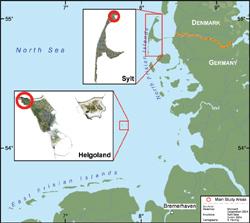
Map overview of the study sites

Poster presentations
  |